
Estland topographic map
Interactive map
Click on the map to display elevation.
About this map
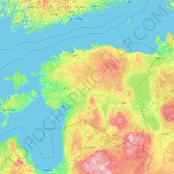
Name: Estland topographic map, elevation, terrain.
Location: Estland (57.50930 21.38261 59.93838 28.21002)
Average elevation: 38 m
Minimum elevation: -3 m
Maximum elevation: 270 m
Estland liegt an der östlichen Küste der Ostsee. Flächenmäßig ist es etwas kleiner als Niedersachsen und etwas größer als die Schweiz. Das seenreiche Wald- und Hügelland mit vielen Mooren (teilweise Gewinnung von Torf) hat eine durchschnittliche Höhe von nur 50 m. Im südöstlichen Moränengebiet steigt es zum livländischen Hügelland bis zur höchsten Erhebung, dem Suur Munamägi (318 Meter), an. Der größte See ist der Peipsi järv (Peipussee), die größten Inseln Saaremaa und Hiiumaa.
Other topographic maps
Click on a map to view its topography, its elevation and its terrain.
Kriilevälja küla
Kriilevälja küla, Kriilevälja, Paide linn, Kreis Jerwen, Estland
Average elevation: 64 m
Vilama küla
Vilama küla, Vilama, Kose vald, Harju maakond, Estland
Average elevation: 69 m