
Goiás topographic map
Interactive map
Click on the map to display elevation.
About this map
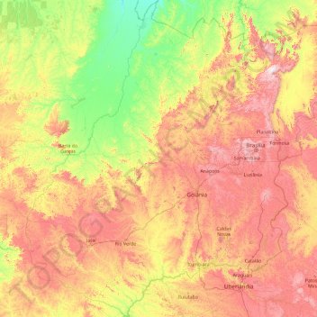
Name: Goiás topographic map, elevation, terrain.
Location: Goiás, Central-West Region, Brazil (-19.49900 -53.25100 -12.39738 -45.90663)
Average elevation: 579 m
Minimum elevation: 200 m
Maximum elevation: 1,605 m
Goiás is covered with a woodland savanna known in Brazil as campo cerrado, although there are still tropical forests along the rivers. This cerrado has been seriously diminished in recent years due to cattle raising and soybean farming with great loss of animal life and forest cover. The climate of the plateau is tropical. Average monthly temperatures vary from 26 °C (79 °F) in the warmest month to 22 °C (72 °F) in the coldest. The year is divided into a rainy season (October–March) and a dry season (April–September). Average annual rainfall is about 1,700 millimetres (67 in), but this varies due to elevation and microclimate. Some parts of the state, however, have small remnants of tropical Atlantic forest, that mostly appears around rivers and valleys.