
Limerlé topographic map
Interactive map
Click on the map to display elevation.
About this map
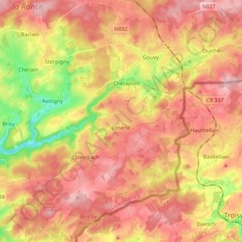
Name: Limerlé topographic map, elevation, terrain.
Location: Limerlé, Gouvy, Bastenaken, Luxemburg, Wallonië, België (50.11023 5.85790 50.20880 5.97285)
Average elevation: 471 m
Minimum elevation: 369 m
Maximum elevation: 538 m
Other topographic maps
Click on a map to view its topography, its elevation and its terrain.
Beho
België > Luxemburg > Bastenaken > Gouvy
Beho, Gouvy, Bastenaken, Luxemburg, Wallonië, 6672, België
Average elevation: 491 m