
Bickerton Hill topographic map
Interactive map
Click on the map to display elevation.
About this map
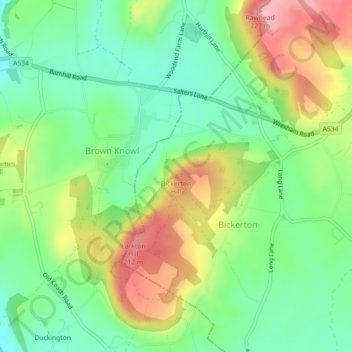
Name: Bickerton Hill topographic map, elevation, terrain.
Average elevation: 134 m
Minimum elevation: 77 m
Maximum elevation: 221 m
Bickerton Hill refers to two low red sandstone hills that form the southern end of the Mid Cheshire Ridge in Cheshire, north-west England. The high point, Raw Head, lies on the northerly hill and has an elevation of 227 metres. Parts of the southerly hill are also known as Larkton Hill.