
Lipa topographic map
Interactive map
Click on the map to display elevation.
About this map
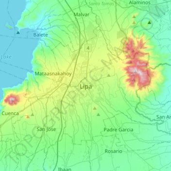
Name: Lipa topographic map, elevation, terrain.
Location: Lipa, Batangas, Calabarzon, Philippines (13.85501 121.06920 14.02987 121.28263)
Average elevation: 248 m
Minimum elevation: -3 m
Maximum elevation: 957 m
At the celebration of the elevation of Lipa to a city in January 1888, José Rizal was invited by Dr. Jose Lozada, Catalino Dimayuga and the brothers Celestino and Simeon Luz but Rizal responded only with his Hymno Al Trabajo which he dedicated to the zeal and industry of the Lipeños.
Other topographic maps
Click on a map to view its topography, its elevation and its terrain.
Kawayan Cove
Philippines > Batangas > Nasugbu
Kawayan Cove, Nasugbu, Batangas, Calabarzon, Philippines
Average elevation: 22 m
Nasugbu
Nasugbu, Batangas, Calabarzon, 4231, Philippines
Average elevation: 71 m
Batangas City
Philippines > Batangas > Batangas City
Batangas City, Batangas, Calabarzon, 4200, Philippines
Average elevation: 65 m
Malaking Tubig River
Malaking Tubig River, Batangas, Calabarzon, Philippines
Average elevation: 5 m
Buso Buso
Philippines > Batangas > Buso Buso
Buso Buso, Batangas, Calabarzon, Philippines
Average elevation: 44 m