
Barbourville topographic map
Interactive map
Click on the map to display elevation.
About this map
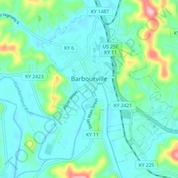
Name: Barbourville topographic map, elevation, terrain.
Location: Barbourville, Knox County, Kentucky, 40906, United States (36.84275 -83.90541 36.88420 -83.84297)
Average elevation: 323 m
Minimum elevation: 286 m
Maximum elevation: 476 m
Other topographic maps
Click on a map to view its topography, its elevation and its terrain.
Walker
United States > Kentucky > Knox County
Walker, Knox County, Kentucky, 40997, United States
Average elevation: 403 m
Hinkle
United States > Kentucky > Knox County
Hinkle, Knox County, Kentucky, 40915, United States
Average elevation: 368 m
Flat Lick
United States > Kentucky > Knox County
Flat Lick, Knox County, Kentucky, 40935, United States
Average elevation: 349 m
Big Rock
United States > Kentucky > Knox County
Big Rock, Knox County, Kentucky, 40923, United States
Average elevation: 355 m
Baughman
United States > Kentucky > Knox County > Baughman
Baughman, Knox County, Kentucky, 40915, United States
Average elevation: 360 m