
La Roche topographic map
Interactive map
Click on the map to display elevation.
About this map
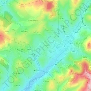
Name: La Roche topographic map, elevation, terrain.
Average elevation: 441 m
Minimum elevation: 366 m
Maximum elevation: 589 m
Other topographic maps
Click on a map to view its topography, its elevation and its terrain.
Le Colin
France > Auvergne-Rhône-Alpes > Rhône > Thizy-les-Bourgs > Bourg-de-Thizy
Le Colin, Bourg-de-Thizy, Thizy-les-Bourgs, Villefranche-sur-Saône, Rhône, Auvergne-Rhône-Alpes, France métropolitaine, 69240, France
Average elevation: 445 m