
St Albans topographic map
Interactive map
Click on the map to display elevation.
About this map
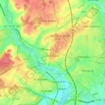
Name: St Albans topographic map, elevation, terrain.
Location: St Albans, Hertfordshire, England, United Kingdom (51.72913 -0.37529 51.78007 -0.29102)
Average elevation: 103 m
Minimum elevation: 69 m
Maximum elevation: 141 m
The borough consisted of the ancient parish of St Albans (also known as the Abbey parish) and parts of the parishes of St Michael and St Peter. The borough was reformed by the Municipal Corporations Act 1835 to become a municipal borough, and the boundary was adjusted to additionally include part of the parish of St Stephen. On 28 August 1877 the borough gained city status, following the elevation of St Albans Abbey to become a cathedral. The boundary was also adjusted in 1877 to include part of the parish of Sandridge.
Other topographic maps
Click on a map to view its topography, its elevation and its terrain.
Baldock
United Kingdom > England > Hertfordshire > North Hertfordshire
Baldock, North Hertfordshire, Hertfordshire, England, SG7 6AS, United Kingdom
Average elevation: 90 m
Hatfield
United Kingdom > England > Hertfordshire > Welwyn Hatfield
Hatfield, Welwyn Hatfield, Hertfordshire, England, United Kingdom
Average elevation: 90 m
Hammond Street
United Kingdom > England > Hertfordshire > Broxbourne
Hammond Street, Broxbourne, Hertfordshire, England, EN7 6WH, United Kingdom
Average elevation: 83 m
Verulamium Lake
United Kingdom > England > Hertfordshire > St Albans
Verulamium Lake, St Stephens, St Albans, Hertfordshire, England, United Kingdom
Average elevation: 102 m
Tyttenhanger
United Kingdom > England > Hertfordshire > St Albans > Colney Heath
Tyttenhanger, Colney Heath, St Albans, Hertfordshire, England, AL4 0RN, United Kingdom
Average elevation: 83 m
Hertford Heath
United Kingdom > England > Hertfordshire > East Hertfordshire
Hertford Heath, East Hertfordshire, Hertfordshire, England, United Kingdom
Average elevation: 74 m
Ware
United Kingdom > England > Hertfordshire > East Hertfordshire
Ware, East Hertfordshire, Hertfordshire, England, United Kingdom
Average elevation: 55 m
Tring
United Kingdom > England > Hertfordshire > Dacorum
Tring, Dacorum, Hertfordshire, England, United Kingdom
Average elevation: 168 m
Stevenage
United Kingdom > England > Hertfordshire
Stevenage, Hertfordshire, England, United Kingdom
Average elevation: 108 m
Stanstead Abbotts
United Kingdom > England > Hertfordshire > East Hertfordshire
Stanstead Abbotts, East Hertfordshire, Hertfordshire, England, SG12 8HU, United Kingdom
Average elevation: 48 m
Letchworth
United Kingdom > England > Hertfordshire
Letchworth, Hertfordshire, England, United Kingdom
Average elevation: 81 m
Bishop's Stortford
United Kingdom > England > Hertfordshire > East Hertfordshire
Bishop's Stortford, East Hertfordshire, Hertfordshire, England, United Kingdom
Average elevation: 83 m
Norton
United Kingdom > England > Hertfordshire > Letchworth
Norton, Letchworth, Hertfordshire, England, SG6 1AG, United Kingdom
Average elevation: 75 m
Middlesex
United Kingdom > England > Hertfordshire
Middlesex, Hertfordshire, Greater London, England, United Kingdom
Average elevation: 46 m
Bovingdon
United Kingdom > England > Hertfordshire > Bovingdon
Bovingdon, Hertfordshire, East of England, England, HP3 0FA, United Kingdom
Average elevation: 150 m
Bushey Heath
United Kingdom > England > Hertfordshire > Hertsmere > Bushey Heath
Bushey Heath, Hertsmere, Hertfordshire, East of England, England, WD23 1SH, United Kingdom
Average elevation: 110 m
Royston
United Kingdom > England > Hertfordshire > North Hertfordshire
Royston, North Hertfordshire, Hertfordshire, England, United Kingdom
Average elevation: 78 m
St Albans
United Kingdom > England > Hertfordshire > St Albans
St Albans, Hertfordshire, East of England, England, United Kingdom
Average elevation: 107 m
Barkway
United Kingdom > England > Hertfordshire > North Hertfordshire
Barkway, North Hertfordshire, Hertfordshire, England, United Kingdom
Average elevation: 119 m
Watford
United Kingdom > England > Hertfordshire
Watford, Hertfordshire, England, United Kingdom
Average elevation: 77 m
Letchworth
United Kingdom > England > Hertfordshire > North Hertfordshire > Letchworth
Letchworth, North Hertfordshire, Hertfordshire, East of England, England, SG6 3BF, United Kingdom
Average elevation: 80 m