
Rafael topographic map
Interactive map
Click on the map to display elevation.
About this map
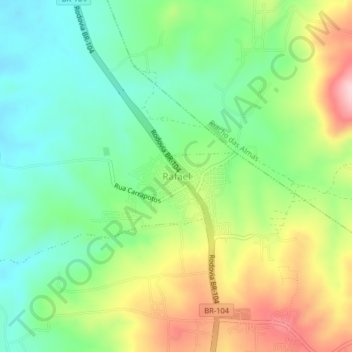
Name: Rafael topographic map, elevation, terrain.
Average elevation: 575 m
Minimum elevation: 486 m
Maximum elevation: 721 m
Other topographic maps
Click on a map to view its topography, its elevation and its terrain.
Caruaru
Brazilië > Pernambuco > Caruaru
Caruaru, Região Geográfica Imediata de Caruaru, Região Geográfica Intermediária de Caruaru, Pernambuco, Regio Noordoost, Brazilië
Average elevation: 535 m