
Westendorf topographic map
Interactive map
Click on the map to display elevation.
About this map
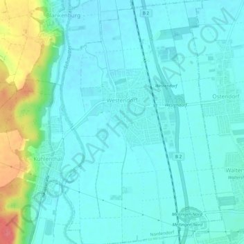
Name: Westendorf topographic map, elevation, terrain.
Average elevation: 433 m
Minimum elevation: 419 m
Maximum elevation: 492 m
Other topographic maps
Click on a map to view its topography, its elevation and its terrain.
Klinge
Duitsland > Beieren > Landkreis Augsburg > Gersthofen
Klinge, Gersthofen, Landkreis Augsburg, Beieren, 86456, Duitsland
Average elevation: 477 m
Welden
Duitsland > Beieren > Landkreis Augsburg
Welden, Landkreis Augsburg, Beieren, 86465, Duitsland
Average elevation: 497 m