
Feldkahl topographic map
Interactive map
Click on the map to display elevation.
About this map
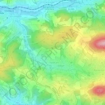
Name: Feldkahl topographic map, elevation, terrain.
Location: Feldkahl, Hösbach, Landkreis Aschaffenburg, Bayern, Deutschland (50.03206 9.18754 50.05607 9.23808)
Average elevation: 245 m
Minimum elevation: 173 m
Maximum elevation: 377 m
Other topographic maps
Click on a map to view its topography, its elevation and its terrain.
Winzenhohl
Deutschland > Bayern > Landkreis Aschaffenburg > Hösbach
Winzenhohl, Schmerlenbach, Hösbach, Landkreis Aschaffenburg, Bayern, 63768, Deutschland
Average elevation: 228 m
Münchhof
Deutschland > Bayern > Landkreis Aschaffenburg > Hösbach > Wenighösbach
Münchhof, Wenighösbach, Hösbach, Landkreis Aschaffenburg, Bayern, 63768, Deutschland
Average elevation: 216 m