
Gaspereau topographic map
Interactive map
Click on the map to display elevation.
About this map
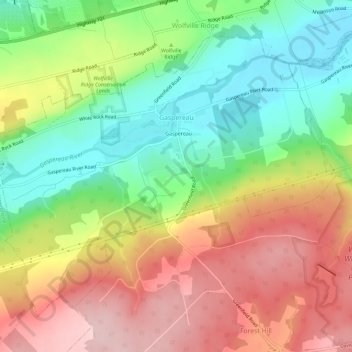
Name: Gaspereau topographic map, elevation, terrain.
Average elevation: 113 m
Minimum elevation: 2 m
Maximum elevation: 237 m
Other topographic maps
Click on a map to view its topography, its elevation and its terrain.
Harmony
Canada > Nova Scotia > Municipality of the County of Kings
Harmony, Municipality of the County of Kings, Kings County, Nova Scotia, B0P 1R0, Canada
Average elevation: 129 m
Aylesford
Canada > Nova Scotia > Municipality of the County of Kings
Aylesford, Municipality of the County of Kings, Kings County, Nova Scotia, B0P 1C0, Canada
Average elevation: 30 m
Tremont
Canada > Nova Scotia > Municipality of the County of Kings
Tremont, Municipality of the County of Kings, Kings County, Nova Scotia, B0P 1R0, Canada
Average elevation: 58 m
Bishopville
Canada > Nova Scotia > Municipality of the County of Kings
Bishopville, Municipality of the County of Kings, Kings County, Nova Scotia, B0P 1P0, Canada
Average elevation: 88 m
Greenwich
Canada > Nova Scotia > Municipality of the County of Kings
Greenwich, Municipality of the County of Kings, Kings County, Nova Scotia, B4P 0B2, Canada
Average elevation: 32 m
Kingston
Canada > Nova Scotia > Municipality of the County of Kings
Kingston, Municipality of the County of Kings, Kings County, Nova Scotia, B0P 1R0, Canada
Average elevation: 30 m
Steam Mill
Canada > Nova Scotia > Municipality of the County of Kings
Steam Mill, Municipality of the County of Kings, Kings County, Nova Scotia, Canada
Average elevation: 22 m
East Margaretsville
Canada > Nova Scotia > Municipality of the County of Kings
East Margaretsville, Municipality of the County of Kings, Kings County, Nova Scotia, B0P 1R0, Canada
Average elevation: 91 m
Lumsden Pond
Canada > Nova Scotia > Municipality of the County of Kings > Lumsden Dam
Lumsden Pond, Lumsden Dam, Municipality of the County of Kings, Kings County, Nova Scotia, Canada
Average elevation: 170 m
Armstrong Lake
Canada > Nova Scotia > Municipality of the County of Kings
Armstrong Lake, Municipality of the County of Kings, Kings County, Nova Scotia, Canada
Average elevation: 208 m
Salmontail Lake
Canada > Nova Scotia > Municipality of the County of Kings
Salmontail Lake, Municipality of the County of Kings, Kings County, Nova Scotia, Canada
Average elevation: 226 m
Hortonville
Canada > Nova Scotia > Municipality of the County of Kings
Hortonville, Municipality of the County of Kings, Kings County, Nova Scotia, Canada
Average elevation: 16 m
Blue Mountain
Canada > Nova Scotia > Municipality of the County of Kings
Blue Mountain, Municipality of the County of Kings, Kings County, Nova Scotia, B4N 3V8, Canada
Average elevation: 224 m
Greenwood
Canada > Nova Scotia > Municipality of the County of Kings
Greenwood, Municipality of the County of Kings, Kings County, Nova Scotia, B0P 1N0, Canada
Average elevation: 28 m
Grand Pre
Canada > Nova Scotia > Municipality of the County of Kings
Grand Pre, Municipality of the County of Kings, Kings County, Nova Scotia, B0P 1M0, Canada
Average elevation: 21 m
North Kingston
Canada > Nova Scotia > Municipality of the County of Kings
North Kingston, Municipality of the County of Kings, Kings County, Nova Scotia, B0P 1R0, Canada
Average elevation: 88 m
Bishopville
Canada > Nova Scotia > Municipality of the County of Kings
Bishopville, Municipality of the County of Kings, Kings County, Nova Scotia, B0P 1P0, Canada
Average elevation: 81 m
Kingsport
Canada > Nova Scotia > Municipality of the County of Kings
Kingsport, Municipality of the County of Kings, Kings County, Nova Scotia, B0P 1T0, Canada
Average elevation: 9 m
Halls Harbour
Canada > Nova Scotia > Municipality of the County of Kings
Halls Harbour, Municipality of the County of Kings, Kings County, Nova Scotia, Canada
Average elevation: 79 m
Frog Lake
Canada > Nova Scotia > Municipality of the County of Kings
Frog Lake, Municipality of the County of Kings, Kings County, Nova Scotia, Canada
Average elevation: 211 m
Factorydale
Canada > Nova Scotia > Municipality of the County of Kings
Factorydale, Municipality of the County of Kings, Kings County, Nova Scotia, B0P 1E0, Canada
Average elevation: 43 m