
Yeager topographic map
Interactive map
Click on the map to display elevation.
About this map
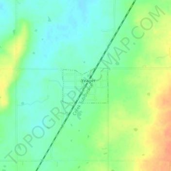
Name: Yeager topographic map, elevation, terrain.
Location: Yeager, Hughes County, Oklahoma, United States (35.15402 -96.34444 35.15957 -96.33567)
Average elevation: 245 m
Minimum elevation: 229 m
Maximum elevation: 268 m
The town lies at an elevation of 870 feet above sea level and has an average of 39 inches of rain and 6.1 inches of snowfall annually.
Other topographic maps
Click on a map to view its topography, its elevation and its terrain.
Calvin
United States > Oklahoma > Hughes County
Calvin, Hughes County, Oklahoma, 74531, United States
Average elevation: 232 m
Wetumka
United States > Oklahoma > Hughes County
Wetumka, Hughes County, Oklahoma, 74883, United States
Average elevation: 235 m
Atwood
United States > Oklahoma > Hughes County
Atwood, Hughes County, Oklahoma, United States
Average elevation: 243 m
Gerty
United States > Oklahoma > Hughes County
Gerty, Hughes County, Oklahoma, United States
Average elevation: 258 m
Horntown
United States > Oklahoma > Hughes County
Horntown, Hughes County, Oklahoma, United States
Average elevation: 255 m
Spaulding
United States > Oklahoma > Hughes County
Spaulding, Hughes County, Oklahoma, United States
Average elevation: 251 m
Dustin
United States > Oklahoma > Hughes County
Dustin, Hughes County, Oklahoma, 74839, United States
Average elevation: 217 m
Lamar
United States > Oklahoma > Hughes County
Lamar, Hughes County, Oklahoma, 74850, United States
Average elevation: 259 m
Stuart
United States > Oklahoma > Hughes County
Stuart, Hughes County, Oklahoma, United States
Average elevation: 229 m
Holdenville
United States > Oklahoma > Hughes County
Holdenville, Hughes County, Oklahoma, 74848, United States
Average elevation: 263 m