
Thank you for supporting this site ❤️
Make a donation
Make a donation
Oberems topographic map
Click on the map to display elevation.
Thank you for supporting this site ❤️
Make a donation
Make a donation
About this map
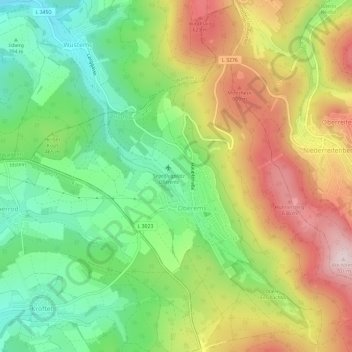
Name: Oberems topographic map, elevation, terrain.
Location: Oberems, Glashütten, Hochtaunuskreis, Hesse, Germany (50.22196 8.37729 50.25888 8.43648)
Average elevation: 480 m
Minimum elevation: 312 m
Maximum elevation: 699 m
Thank you for supporting this site ❤️
Make a donation
Make a donation