
Fiscal topographic map
Interactive map
Click on the map to display elevation.
About this map
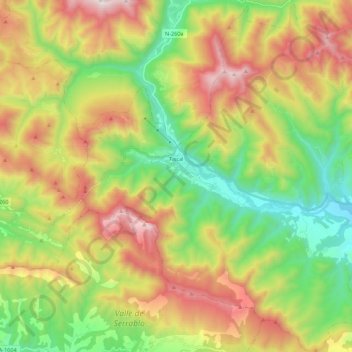
Name: Fiscal topographic map, elevation, terrain.
Location: Fiscal, Sobrarbe, Huesca, Aragão, 22373, Espanha (42.40784 -0.18298 42.56743 0.03498)
Average elevation: 1,227 m
Minimum elevation: 656 m
Maximum elevation: 2,020 m
Other topographic maps
Click on a map to view its topography, its elevation and its terrain.
Punta de Treserols / Monte Perdido
Espanha > Aragão > Sobrarbe > Bielsa
Punta de Treserols / Monte Perdido, Bielsa, Sobrarbe, Huesca, Aragão, Espanha
Average elevation: 2,806 m