
Thank you for supporting this site ❤️
Make a donation
Make a donation
Charleston topographic map
Click on the map to display elevation.
Thank you for supporting this site ❤️
Make a donation
Make a donation
About this map
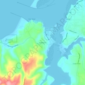
Name: Charleston topographic map, elevation, terrain.
Location: Charleston, Coos County, Oregon, 92443, United States (43.32001 -124.35024 43.36001 -124.31024)
Average elevation: 24 m
Minimum elevation: -5 m
Maximum elevation: 132 m
Thank you for supporting this site ❤️
Make a donation
Make a donation
Other topographic maps
Click on a map to view its topography, its elevation and its terrain.