
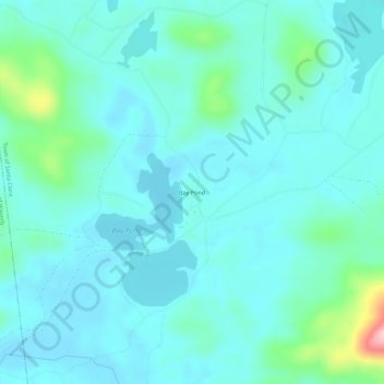
Bay Pond topographic map
Interactive map
Click on the map to display elevation.
About this map
Name: Bay Pond topographic map, elevation, terrain.
Average elevation: 494 m
Minimum elevation: 464 m
Maximum elevation: 661 m
Other topographic maps
Click on a map to view its topography, its elevation and its terrain.
St. Regis Falls
United States > New York > Franklin County
St. Regis Falls, Town of Waverly, Franklin County, New York, United States
Average elevation: 386 m
Lake Clear
United States > New York > Franklin County
Lake Clear, Town of Harrietstown, Franklin County, New York, 12945, United States
Average elevation: 498 m
Town of Chateaugay
United States > New York > Franklin County
Town of Chateaugay, Franklin County, New York, 12920, United States
Average elevation: 280 m
Village of Burke
United States > New York > Franklin County > Town of Burke
Village of Burke, Town of Burke, Franklin County, New York, United States
Average elevation: 263 m
Village of Brushton
United States > New York > Franklin County
Village of Brushton, Town of Moira, Franklin County, New York, United States
Average elevation: 132 m
Rainbow Lake
United States > New York > Franklin County
Rainbow Lake, Town of Brighton, Franklin County, New York, 12976, United States
Average elevation: 536 m
Akwesasne
United States > New York > Franklin County > Town of Bombay
Akwesasne, Town of Bombay, Franklin County, New York, United States
Average elevation: 57 m
North Bangor
United States > New York > Franklin County > Town of Bangor
North Bangor, Town of Bangor, Franklin County, New York, 12966, United States
Average elevation: 204 m
Hogansburg
United States > New York > Franklin County > Town of Bombay
Hogansburg, Town of Bombay, Franklin County, New York, 13655, United States
Average elevation: 55 m
South Bombay
United States > New York > Franklin County > Town of Bombay
South Bombay, Town of Bombay, Franklin County, New York, 12957, United States
Average elevation: 83 m
Gabriels
United States > New York > Franklin County
Gabriels, Town of Brighton, Franklin County, New York, 12939, United States
Average elevation: 530 m
Owls Head
United States > New York > Franklin County
Owls Head, Town of Bellmont, Franklin County, New York, 12969, United States
Average elevation: 554 m
Upper Saint Regis Lake
United States > New York > Franklin County > Town of Harrietstown
Upper Saint Regis Lake, Town of Harrietstown, Town of Brighton, Franklin County, New York, United States
Average elevation: 506 m
Upper Saint Regis
United States > New York > Franklin County > Town of Harrietstown
Upper Saint Regis, Town of Harrietstown, Franklin County, New York, 12945, United States
Average elevation: 509 m
Vermontville
United States > New York > Franklin County
Vermontville, Town of Franklin, Franklin County, New York, 12913, United States
Average elevation: 527 m
Town of Duane
United States > New York > Franklin County
Town of Duane, Franklin County, New York, United States
Average elevation: 511 m
Village of Malone
United States > New York > Franklin County > Town of Malone
Village of Malone, Town of Malone, Franklin County, New York, United States
Average elevation: 234 m
Town of Bombay
United States > New York > Franklin County
Town of Bombay, Franklin County, New York, United States
Average elevation: 66 m
Village of Saranac Lake
United States > New York > Franklin County > Town of Harrietstown
Village of Saranac Lake, Town of Harrietstown, Franklin County, New York, United States
Average elevation: 502 m
Town of Fort Covington
United States > New York > Franklin County
Town of Fort Covington, Franklin County, New York, United States
Average elevation: 69 m
Town of Bangor
United States > New York > Franklin County
Town of Bangor, Franklin County, New York, 12966, United States
Average elevation: 209 m
Town of Waverly
United States > New York > Franklin County
Town of Waverly, Franklin County, New York, 12980, United States
Average elevation: 454 m
Town of Santa Clara
United States > New York > Franklin County
Town of Santa Clara, Franklin County, New York, United States
Average elevation: 478 m
Paul Smiths
United States > New York > Franklin County
Paul Smiths, Town of Brighton, Franklin County, New York, United States
Average elevation: 503 m
Fish Creek Pond Campground
United States > New York > Franklin County > Santa Clara
Fish Creek Pond Campground, Santa Clara, Franklin County, New York, United States
Average elevation: 488 m
Town of Constable
United States > New York > Franklin County
Town of Constable, Franklin County, New York, 12926, United States
Average elevation: 111 m
Saginaw Bay
United States > New York > Franklin County > Santa Clara
Saginaw Bay, Santa Clara, Franklin County, New York, United States
Average elevation: 504 m
Lost Mountain
United States > New York > Franklin County
Lost Mountain, Town of Waverly, Franklin County, New York, United States
Average elevation: 557 m
Lake Titus
United States > New York > Franklin County > Town of Malone
Lake Titus, Town of Malone, Franklin County, New York, United States
Average elevation: 463 m
Chasm Falls
United States > New York > Franklin County > Chasm Falls
Chasm Falls, Malone, Franklin County, New York, United States
Average elevation: 404 m
Dickinson Center
United States > New York > Franklin County
Dickinson Center, Town of Dickinson, Franklin County, New York, 12930, United States
Average elevation: 295 m
Meacham Lake
United States > New York > Franklin County
Meacham Lake, Duane, Franklin County, New York, United States
Average elevation: 489 m
Simon Pond
United States > New York > Franklin County
Simon Pond, Franklin County, New York, United States
Average elevation: 502 m
Town of Moira
United States > New York > Franklin County
Town of Moira, Franklin County, New York, United States
Average elevation: 123 m
Harrietstown
United States > New York > Franklin County > Harrietstown
Harrietstown, Franklin County, New York, 12939, United States
Average elevation: 512 m
Osgood Pond
United States > New York > Franklin County > Paul Smiths
Osgood Pond, Paul Smiths, Franklin County, New York, United States
Average elevation: 516 m
Lower Saranac Lake
United States > New York > Franklin County
Lower Saranac Lake, Franklin County, New York, United States
Average elevation: 507 m
Westville Center
United States > New York > Franklin County > Westville Center
Westville Center, Franklin County, New York, United States
Average elevation: 75 m
Lower Chateaugay Lake
United States > New York > Franklin County > Town of Ellenburg
Lower Chateaugay Lake, Town of Ellenburg, Town of Bellmont, Franklin County, New York, United States
Average elevation: 487 m
Middle Saranac Lake
United States > New York > Franklin County
Middle Saranac Lake, Franklin County, New York, United States
Average elevation: 484 m
Stony Creek
United States > New York > Franklin County
Stony Creek, Franklin County, New York, United States
Average elevation: 492 m
Mountain View Lake
United States > New York > Franklin County > Mountain View
Mountain View Lake, Mountain View, Franklin County, New York, United States
Average elevation: 472 m
Lake Colby
United States > New York > Franklin County > Lake Colby
Lake Colby, Franklin County, New York, 12983, United States
Average elevation: 506 m
Village of Tupper Lake
United States > New York > Franklin County
Village of Tupper Lake, Town of Tupper Lake, Franklin County, New York, 12986, United States
Average elevation: 484 m
Loon Lake
United States > New York > Franklin County > Loon Lake
Loon Lake, Franklin County, New York, United States
Average elevation: 517 m