
Columbia topographic map
Interactive map
Click on the map to display elevation.
Columbia
The city has capitalized on this location, which includes three rivers, by identifying as "The Columbia Riverbanks Region". Columbia is located roughly halfway between the Atlantic Ocean and the Blue Ridge Mountains, at an elevation around 292 ft (89 m).
About this map
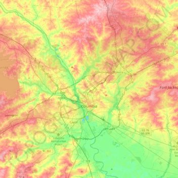
Name: Columbia topographic map, elevation, terrain.
Location: Columbia, Richland County, South Carolina, United States (33.94325 -81.17098 34.13160 -80.70382)
Average elevation: 89 m
Minimum elevation: 7 m
Maximum elevation: 174 m