
Thank you for supporting this site ❤️
Make a donation
Make a donation
Leduc County topographic map
Click on the map to display elevation.
Thank you for supporting this site ❤️
Make a donation
Make a donation
About this map
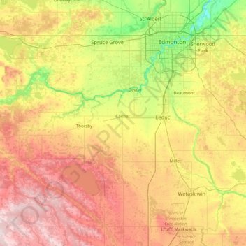
Name: Leduc County topographic map, elevation, terrain.
Location: Leduc County, Alberta, Canada (53.04671 -114.56240 53.42903 -113.00111)
Average elevation: 773 m
Minimum elevation: 602 m
Maximum elevation: 1,041 m
Thank you for supporting this site ❤️
Make a donation
Make a donation
Other topographic maps
Click on a map to view its topography, its elevation and its terrain.