
Thank you for supporting this site ❤️
Make a donation
Make a donation
Sparks Lake topographic map
Click on the map to display elevation.
Thank you for supporting this site ❤️
Make a donation
Make a donation
About this map
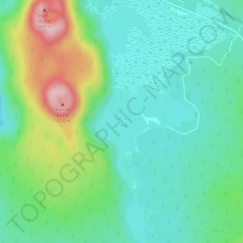
Name: Sparks Lake topographic map, elevation, terrain.
Location: Sparks Lake, Deschutes County, Oregon, United States (43.99887 -121.75166 44.03024 -121.73314)
Average elevation: 1,696 m
Minimum elevation: 1,632 m
Maximum elevation: 1,858 m
Thank you for supporting this site ❤️
Make a donation
Make a donation
Other topographic maps
Click on a map to view its topography, its elevation and its terrain.
Three Sisters
United States > Oregon > Deschutes County
The Three Sisters are closely spaced volcanic peaks in the U.S. state of Oregon. They are part of the Cascade Volcanic Arc, a segment of the Cascade Range in western North America extending from southern British Columbia through Washington and Oregon to Northern California. Each more than 10,000 feet (3,000 m)…
Average elevation: 2,526 m