
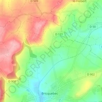
La Croix Blanche topographic map
Interactive map
Click on the map to display elevation.
About this map
Name: La Croix Blanche topographic map, elevation, terrain.
Average elevation: 89 m
Minimum elevation: 32 m
Maximum elevation: 163 m
Other topographic maps
Click on a map to view its topography, its elevation and its terrain.
Le Melleret
France > Normandie > Manche > Bricquebec-en-Cotentin > Bricquebec
Le Melleret, Bricquebec, Bricquebec-en-Cotentin, Cherbourg, Manche, Normandie, France métropolitaine, 50260, France
Average elevation: 57 m
Le Melleret
France > Normandie > Manche > Bricquebec-en-Cotentin > Bricquebec
Le Melleret, Bricquebec, Bricquebec-en-Cotentin, Cherbourg, Manche, Normandie, France métropolitaine, 50260, France
Average elevation: 58 m
Catigny
France > Normandie > Manche > Bricquebec-en-Cotentin > Bricquebec > Catigny
Catigny, Bricquebec, Bricquebec-en-Cotentin, Cherbourg, Manche, Normandie, France métropolitaine, 50260, France
Average elevation: 104 m