
Freckenhorst topographic map
Interactive map
Click on the map to display elevation.
About this map
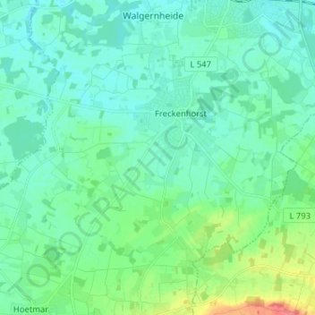
Name: Freckenhorst topographic map, elevation, terrain.
Average elevation: 66 m
Minimum elevation: 53 m
Maximum elevation: 114 m
Other topographic maps
Click on a map to view its topography, its elevation and its terrain.
Vohren
Deutschland > Nordrhein-Westfalen > Warendorf > Vohren
Vohren, Warendorf, Kreis Warendorf, Nordrhein-Westfalen, Deutschland
Average elevation: 58 m
Hoetmar
Deutschland > Nordrhein-Westfalen > Warendorf
Hoetmar, Warendorf, Kreis Warendorf, Regierungsbezirk Münster, Nordrhein-Westfalen, Deutschland
Average elevation: 69 m
Schloss Westerholt
Deutschland > Nordrhein-Westfalen > Warendorf
Schloss Westerholt, 10, Everwordstraße, Freckenhorst, Warendorf, Kreis Warendorf, Regierungsbezirk Münster, Nordrhein-Westfalen, 48231, Deutschland
Average elevation: 61 m