
Inanda topographic map
Interactive map
Click on the map to display elevation.
About this map
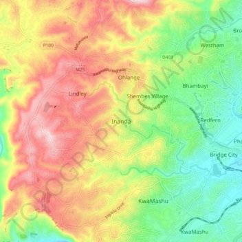
Name: Inanda topographic map, elevation, terrain.
Average elevation: 200 m
Minimum elevation: 30 m
Maximum elevation: 395 m
Other topographic maps
Click on a map to view its topography, its elevation and its terrain.
eThekwini Ward 44
RSA > KwaZulu-Natal > Inanda
eThekwini Ward 44, Inanda, eThekwini Metropolitan Municipality, KwaZulu-Natal, RSA
Average elevation: 230 m