
Thank you for supporting this site ❤️
Make a donation
Make a donation
Uzice topographic map
Click on the map to display elevation.
Thank you for supporting this site ❤️
Make a donation
Make a donation
About this map
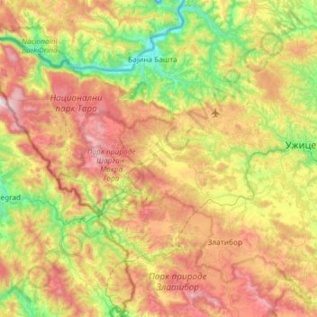
Name: Uzice topographic map, elevation, terrain.
Average elevation: 684 m
Minimum elevation: 204 m
Maximum elevation: 1,470 m
Thank you for supporting this site ❤️
Make a donation
Make a donation
Other topographic maps
Click on a map to view its topography, its elevation and its terrain.
Валеница
Serbia > Zlatibor Administrative District > Prijepolje Municipality
Average elevation: 1,474 m
Mali Povlen
Serbia > Zlatibor Administrative District > Kosjeric Municipality
Average elevation: 1,139 m
Thank you for supporting this site ❤️
Make a donation
Make a donation
Валеница
Serbia > Zlatibor Administrative District > Prijepolje Municipality
Average elevation: 1,474 m