
Powers topographic map
Interactive map
Click on the map to display elevation.
About this map
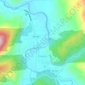
Name: Powers topographic map, elevation, terrain.
Location: Powers, Coos County, Oregon, 97466, United States (42.87646 -124.08148 42.89626 -124.06288)
Average elevation: 145 m
Minimum elevation: 57 m
Maximum elevation: 443 m
Other topographic maps
Click on a map to view its topography, its elevation and its terrain.
Bandon
United States > Oregon > Coos County
Bandon, Coos County, Oregon, United States
Average elevation: 22 m
Charleston
United States > Oregon > Coos County
Charleston, Coos County, Oregon, 92443, United States
Average elevation: 24 m
Coos Bay
United States > Oregon > Coos County
Coos Bay, Coos County, Oregon, 97420, United States
Average elevation: 30 m
William M. Tugman State Park
United States > Oregon > Coos County
William M. Tugman State Park, Wildwood Drive, Coos County, Oregon, 97449, United States
Average elevation: 56 m
Tenmile
United States > Oregon > Coos County
Tenmile, Coos County, Oregon, 97449, United States
Average elevation: 25 m
Allegany
United States > Oregon > Coos County
Allegany, Coos County, Oregon, United States
Average elevation: 118 m
Saunders Lake
United States > Oregon > Coos County
Saunders Lake, Coos County, Oregon, United States
Average elevation: 35 m
Glasgow
United States > Oregon > Coos County
Glasgow, Coos County, Oregon, 97459, United States
Average elevation: 29 m
Myrtle Point
United States > Oregon > Coos County
Myrtle Point, Coos County, Oregon, United States
Average elevation: 33 m
Broadbent
United States > Oregon > Coos County
Broadbent, Coos County, Oregon, 97414, United States
Average elevation: 68 m
Fairview
United States > Oregon > Coos County
Fairview, Coos County, Oregon, United States
Average elevation: 95 m
Bridge
United States > Oregon > Coos County
Bridge, Coos County, Oregon, 97458, United States
Average elevation: 142 m
Barview
United States > Oregon > Coos County
Barview, Coos County, Oregon, United States
Average elevation: 16 m
North Bend
United States > Oregon > Coos County
North Bend, Coos County, Oregon, United States
Average elevation: 11 m
Lakeside
United States > Oregon > Coos County
Lakeside, Coos County, Oregon, 97449, United States
Average elevation: 32 m
Coquille
United States > Oregon > Coos County
Coquille, Coos County, Oregon, United States
Average elevation: 40 m
Judge Hamilton County Park
United States > Oregon > Coos County
Judge Hamilton County Park, Coos County, Oregon, United States
Average elevation: 421 m
Dora
United States > Oregon > Coos County
Dora, Coos County, Oregon, United States
Average elevation: 181 m
Bunker Hill
United States > Oregon > Coos County
Bunker Hill, Coos County, Oregon, United States
Average elevation: 20 m
Randolph
United States > Oregon > Coos County > Randolph
Randolph, Coos County, Oregon, United States
Average elevation: 36 m
Bay Park
United States > Oregon > Coos County > Bay Park
Bay Park, Coos County, Oregon, 870, United States
Average elevation: 27 m