
Manadas (Santa Bárbara) topographic map
Interactive map
Click on the map to display elevation.
About this map
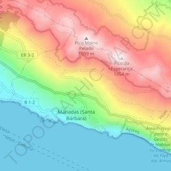
Name: Manadas (Santa Bárbara) topographic map, elevation, terrain.
Location: Manadas (Santa Bárbara), Velas, Açores, 9800-021, Portugal (38.62572 -28.11692 38.65927 -28.05219)
Average elevation: 427 m
Minimum elevation: 0 m
Maximum elevation: 1,039 m
Other topographic maps
Click on a map to view its topography, its elevation and its terrain.
Toledo
Portugal > Velas > Santo Amaro
Toledo, Santo Amaro, Velas, Açores, 9800-338, Portugal
Average elevation: 374 m
Norte Grande (Neves)
Norte Grande (Neves), Velas, Açores, Portugal
Average elevation: 298 m
Urzelina (São Mateus)
Urzelina (São Mateus), Velas, Açores, Portugal
Average elevation: 397 m