
Coralville topographic map
Interactive map
Click on the map to display elevation.
About this map
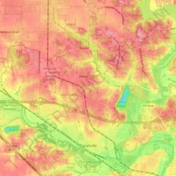
Name: Coralville topographic map, elevation, terrain.
Location: Coralville, Johnson County, Iowa, 52241, United States (41.66628 -91.64696 41.73358 -91.54908)
Average elevation: 224 m
Minimum elevation: 162 m
Maximum elevation: 255 m
Other topographic maps
Click on a map to view its topography, its elevation and its terrain.
Iowa City
United States > Iowa > Johnson County
Iowa City, Johnson County, Iowa, United States
Average elevation: 216 m
Amish
United States > Iowa > Johnson County
Amish, Johnson County, Iowa, United States
Average elevation: 224 m
North Liberty
United States > Iowa > Johnson County
North Liberty, Johnson County, Iowa, 52317, United States
Average elevation: 235 m
Iowa City
United States > Iowa > Johnson County > Iowa City
Iowa City, Johnson County, Iowa, 52240-5544, United States
Average elevation: 225 m
Tiffin
United States > Iowa > Johnson County
Tiffin, Johnson County, Iowa, 52340, United States
Average elevation: 227 m
Clear Creek Township
United States > Iowa > Johnson County
Clear Creek Township, Johnson County, Iowa, United States
Average elevation: 232 m
Swisher
United States > Iowa > Johnson County > Swisher
Swisher, Johnson County, Iowa, United States
Average elevation: 246 m
Solon
United States > Iowa > Johnson County
Solon, Johnson County, Iowa, United States
Average elevation: 238 m
Monroe Township
United States > Iowa > Johnson County
Monroe Township, Johnson County, Iowa, United States
Average elevation: 234 m
Hills
United States > Iowa > Johnson County
Hills, Johnson County, Iowa, 52235, United States
Average elevation: 196 m
Lone Tree
United States > Iowa > Johnson County
Lone Tree, Johnson County, Iowa, United States
Average elevation: 215 m
University Heights
United States > Iowa > Johnson County
University Heights, Johnson County, Iowa, United States
Average elevation: 218 m