
Thank you for supporting this site ❤️
Make a donation
Make a donation
Walsrode topographic map
Click on the map to display elevation.
Thank you for supporting this site ❤️
Make a donation
Make a donation
About this map
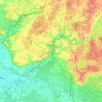
Name: Walsrode topographic map, elevation, terrain.
Location: Walsrode, Heidekreis, Lower Saxony, Germany (52.72520 9.37540 52.97042 9.72059)
Average elevation: 48 m
Minimum elevation: 16 m
Maximum elevation: 106 m
Thank you for supporting this site ❤️
Make a donation
Make a donation
Other topographic maps
Click on a map to view its topography, its elevation and its terrain.
Lüneburg Heath
Germany > Lower Saxony > Heidekreis > Soltau > Hötzingen > Emhof
Average elevation: 85 m
Thank you for supporting this site ❤️
Make a donation
Make a donation