
Briartown topographic map
Interactive map
Click on the map to display elevation.
About this map
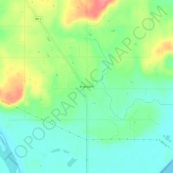
Name: Briartown topographic map, elevation, terrain.
Location: Briartown, Muskogee County, Oklahoma, 74472, United States (35.27774 -95.25876 35.31774 -95.21876)
Average elevation: 172 m
Minimum elevation: 143 m
Maximum elevation: 224 m
Other topographic maps
Click on a map to view its topography, its elevation and its terrain.
Porum
United States > Oklahoma > Muskogee County
Porum, Muskogee County, Oklahoma, 74455, United States
Average elevation: 181 m
Muskogee
United States > Oklahoma > Muskogee County
Muskogee, Muskogee County, Oklahoma, United States
Average elevation: 176 m
Warner
United States > Oklahoma > Muskogee County
Warner, Muskogee County, Oklahoma, 74469, United States
Average elevation: 174 m
Braggs
United States > Oklahoma > Muskogee County
Braggs, Muskogee County, Oklahoma, 74423, United States
Average elevation: 174 m
Ross Lake
United States > Oklahoma > Muskogee County > Fort Gibson
Ross Lake, Fort Gibson, Muskogee County, Oklahoma, United States
Average elevation: 156 m
Fort Gibson
United States > Oklahoma > Muskogee County > Fort Gibson
Fort Gibson, Lee Street, Fort Gibson, Muskogee County, Oklahoma, 74434, United States
Average elevation: 162 m
Muskogee
United States > Oklahoma > Muskogee County > Muskogee
Muskogee, Muskogee County, Oklahoma, 74401, United States
Average elevation: 177 m
Webbers Falls
United States > Oklahoma > Muskogee County
Webbers Falls, Muskogee County, Oklahoma, 74470, United States
Average elevation: 147 m