
Wichelen topographic map
Interactive map
Click on the map to display elevation.
About this map
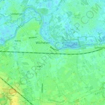
Name: Wichelen topographic map, elevation, terrain.
Location: Wichelen, Dendermonde, Oost-Vlaanderen, Vlaanderen, 9360, België (50.98026 3.95630 51.02379 4.00634)
Average elevation: 7 m
Minimum elevation: -4 m
Maximum elevation: 20 m
Other topographic maps
Click on a map to view its topography, its elevation and its terrain.
Schellebelle
België > Oost-Vlaanderen > Dendermonde > Wichelen
Schellebelle, Wichelen, Dendermonde, Oost-Vlaanderen, Vlaanderen, 9260, België
Average elevation: 7 m
Serskamp
België > Oost-Vlaanderen > Dendermonde > Wichelen > Serskamp
Serskamp, Wichelen, Dendermonde, Oost-Vlaanderen, België
Average elevation: 14 m