
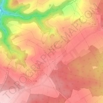
Belg topographic map
Interactive map
Click on the map to display elevation.
About this map
Name: Belg topographic map, elevation, terrain.
Average elevation: 426 m
Minimum elevation: 269 m
Maximum elevation: 489 m
Other topographic maps
Click on a map to view its topography, its elevation and its terrain.
Gondershausen
Duitsland > Rijnland-Palts > Rhein-Hunsrück-Kreis > Gondershausen
Gondershausen, Hunsrück-Mittelrhein, Rhein-Hunsrück-Kreis, Rijnland-Palts, Duitsland
Average elevation: 360 m
Sankt Goar
Duitsland > Rijnland-Palts > Rhein-Hunsrück-Kreis
Sankt Goar, Hunsrück-Mittelrhein, Rhein-Hunsrück-Kreis, Rijnland-Palts, Duitsland
Average elevation: 232 m