
Praia Verde topographic map
Interactive map
Click on the map to display elevation.
About this map
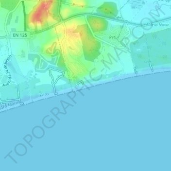
Name: Praia Verde topographic map, elevation, terrain.
Location: Praia Verde, Castro Marim, Faro, Portugal (37.17298 -7.48210 37.17493 -7.47576)
Average elevation: 7 m
Minimum elevation: 0 m
Maximum elevation: 49 m
Other topographic maps
Click on a map to view its topography, its elevation and its terrain.
Alta Mora
Portugal > Faro > Castro Marim
Alta Mora, Castro Marim, Faro, Portugal
Average elevation: 192 m
Azinhal
Portugal > Faro > Castro Marim
Azinhal, Castro Marim, Faro, 8950-032, Portugal
Average elevation: 65 m
São Bartolomeu
Portugal > Faro > Castro Marim
São Bartolomeu, Castro Marim, Faro, 8950-256, Portugal
Average elevation: 17 m
Praia do Cabeço
Portugal > Faro > Castro Marim
Praia do Cabeço, Castro Marim, Faro, Portugal
Average elevation: 7 m
Praia da Alagoa
Portugal > Faro > Castro Marim
Praia da Alagoa, Altura, Castro Marim, Faro, Portugal
Average elevation: 5 m