
Bitz topographic map
Interactive map
Click on the map to display elevation.
About this map
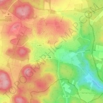
Name: Bitz topographic map, elevation, terrain.
Average elevation: 867 m
Minimum elevation: 780 m
Maximum elevation: 929 m
Other topographic maps
Click on a map to view its topography, its elevation and its terrain.
Schömberg
Duitsland > Baden-Württemberg > Zollernalbkreis
Schömberg, GVV Oberes Schlichemtal, Zollernalbkreis, Baden-Württemberg, 72355, Duitsland
Average elevation: 732 m
Tannenburg
Duitsland > Baden-Württemberg > Zollernalbkreis > Haigerloch > Weildorf > Tannenburg
Tannenburg, Weildorf, Haigerloch, Zollernalbkreis, Baden-Württemberg, 72401, Duitsland
Average elevation: 516 m