
Serra da Estrela Nature Park topographic map
Interactive map
Click on the map to display elevation.
About this map
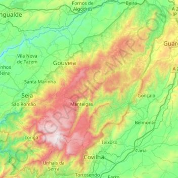
Name: Serra da Estrela Nature Park topographic map, elevation, terrain.
Average elevation: 740 m
Minimum elevation: 198 m
Maximum elevation: 1,989 m
Serra da Estrela Natural Park is situated in the largest mountain range in Portugal - the Serra da Estrela, and is the source of the rivers Mondego, Zêzere (tributary of the Tagus), and Alva. The park is the largest natural conservation area in Portugal and occupies about 1,000 km2. More than half of its area is located above an altitude of 700 m. At 1,993 m it contains the highest peak in Continental Portugal (named Torre) and a ski resort (named Vodafone Ski Resort).
Other topographic maps
Click on a map to view its topography, its elevation and its terrain.
Vila Franca da Serra
Vila Franca da Serra, Gouveia, Guarda, Portugal
Average elevation: 402 m