Geolocate

Güntersberge topographic map

Interactive map

Click on the map to display elevation.

About this map

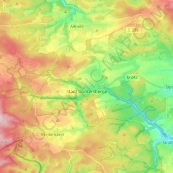
Name: Güntersberge topographic map, elevation, terrain.

Location: Güntersberge, Harzgerode, Landkreis Harz, Sachsen-Anhalt, Deutschland (51.61161 10.89704 51.67971 11.04514)

Average elevation: 467 m

Minimum elevation: 361 m

Maximum elevation: 593 m

Neben der eigentlichen Ortslage Güntersberge (651 Einwohner) gehören noch die Ansiedlungen Friedrichshöhe (41 Einwohner) und Bärenrode (21 Einwohner) zum Ortsteil. (Einwohner Stand 2019)

Wikipedia (CC-BY-SA 3.0)

Other topographic maps

Click on a map to view its topography, its elevation and its terrain.

Pfaffenberg

Deutschland > Sachsen-Anhalt > Landkreis Harz > Harzgerode

Pfaffenberg, Harzgerode, Landkreis Harz, Sachsen-Anhalt, Deutschland

Average elevation: 382 m

Siptenfelde

Deutschland > Sachsen-Anhalt > Landkreis Harz > Harzgerode

Siptenfelde, Harzgerode, Landkreis Harz, Sachsen-Anhalt, Deutschland

Average elevation: 432 m

Dankerode

Deutschland > Sachsen-Anhalt > Landkreis Harz > Harzgerode

Dankerode, Harzgerode, Landkreis Harz, Sachsen-Anhalt, Deutschland

Average elevation: 396 m

-berg

Deutschland > Sachsen-Anhalt > Landkreis Harz > Harzgerode

-berg, Güntersberge, Harzgerode, Landkreis Harz, Sachsen-Anhalt, Deutschland

Average elevation: 471 m

Schielo

Deutschland > Sachsen-Anhalt > Landkreis Harz > Harzgerode

Schielo, Harzgerode, Landkreis Harz, Sachsen-Anhalt, Deutschland

Average elevation: 372 m

Silberhütte

Deutschland > Sachsen-Anhalt > Landkreis Harz > Harzgerode

Silberhütte, Harzgerode, Landkreis Harz, Sachsen-Anhalt, Deutschland

Average elevation: 396 m

Küchenholz

Deutschland > Sachsen-Anhalt > Landkreis Harz > Harzgerode

Küchenholz, Schielo, Harzgerode, Landkreis Harz, Sachsen-Anhalt, 06493, Deutschland

Average elevation: 379 m

Alexisbad

Deutschland > Sachsen-Anhalt > Landkreis Harz > Harzgerode

Alexisbad, Harzgerode, Landkreis Harz, Sachsen-Anhalt, Deutschland

Average elevation: 383 m