
Chammünster topographic map
Interactive map
Click on the map to display elevation.
About this map
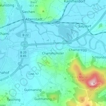
Name: Chammünster topographic map, elevation, terrain.
Location: Chammünster, Cham, Landkreis Cham, Bayern, 93413, Deutschland (49.19042 12.67515 49.23042 12.71515)
Average elevation: 399 m
Minimum elevation: 366 m
Maximum elevation: 592 m
Other topographic maps
Click on a map to view its topography, its elevation and its terrain.
Selling
Deutschland > Bayern > Landkreis Cham > Cham > Kothmaißling
Selling, Kothmaißling, Cham, Landkreis Cham, Bayern, 93486, Deutschland
Average elevation: 399 m
Haidhäuser
Deutschland > Bayern > Landkreis Cham > Cham
Haidhäuser, Cham, Landkreis Cham, Bayern, Deutschland
Average elevation: 381 m
Gutmaning
Deutschland > Bayern > Landkreis Cham > Cham
Gutmaning, Cham, Landkreis Cham, Bayern, 93413, Deutschland
Average elevation: 412 m
Laichstätt
Deutschland > Bayern > Landkreis Cham > Cham
Laichstätt, Cham, Landkreis Cham, Bayern, 93482, Deutschland
Average elevation: 374 m