
Midlothian topographic map
Interactive map
Click on the map to display elevation.
About this map
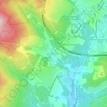
Name: Midlothian topographic map, elevation, terrain.
Location: Midlothian, Allegany County, Maryland, 21543, United States (39.61425 -78.97002 39.65425 -78.93002)
Average elevation: 638 m
Minimum elevation: 526 m
Maximum elevation: 864 m
Other topographic maps
Click on a map to view its topography, its elevation and its terrain.
Frostburg
United States > Maryland > Allegany County
Frostburg, Allegany County, Maryland, 21532, United States
Average elevation: 620 m
Bel Air
United States > Maryland > Allegany County
Bel Air, Allegany County, Maryland, United States
Average elevation: 263 m
Oldtown
United States > Maryland > Allegany County
Oldtown, Allegany County, Maryland, 26722, United States
Average elevation: 194 m
Cresaptown
United States > Maryland > Allegany County
Cresaptown, Allegany County, Maryland, United States
Average elevation: 258 m
Green Ridge State Forest
United States > Maryland > Allegany County
Green Ridge State Forest, Allegany County, Maryland, United States
Average elevation: 295 m
Moscow
United States > Maryland > Allegany County
Moscow, Allegany County, Maryland, 21521, United States
Average elevation: 544 m
Westernport
United States > Maryland > Allegany County
Westernport, Allegany County, Maryland, United States
Average elevation: 400 m
Franklin
United States > Maryland > Allegany County
Franklin, Allegany County, Maryland, 26750, United States
Average elevation: 453 m
McCoole
United States > Maryland > Allegany County
McCoole, Allegany County, Maryland, 26726, United States
Average elevation: 288 m
McKenzie
United States > Maryland > Allegany County
McKenzie, Allegany County, Maryland, United States
Average elevation: 279 m
Carlos
United States > Maryland > Allegany County
Carlos, Allegany County, Maryland, 21543, United States
Average elevation: 635 m
Eckhart Mines
United States > Maryland > Allegany County
Eckhart Mines, Allegany County, Maryland, 21528, United States
Average elevation: 573 m
Pleasant Grove
United States > Maryland > Allegany County
Pleasant Grove, Allegany County, Maryland, United States
Average elevation: 319 m
Pinto
United States > Maryland > Allegany County > Bel Air
Pinto, Bel Air, Allegany County, Maryland, United States
Average elevation: 247 m
Bier
United States > Maryland > Allegany County
Bier, Allegany County, Maryland, United States
Average elevation: 286 m
Bowmans Addition
United States > Maryland > Allegany County
Bowmans Addition, Allegany County, Maryland, 21529, United States
Average elevation: 345 m
Dawson
United States > Maryland > Allegany County
Dawson, Allegany County, Maryland, 21557, United States
Average elevation: 324 m
Ocean
United States > Maryland > Allegany County
Ocean, Allegany County, Maryland, 21542, United States
Average elevation: 593 m
Spring Gap
United States > Maryland > Allegany County
Spring Gap, Allegany County, Maryland, 21560, United States
Average elevation: 218 m
Barton
United States > Maryland > Allegany County
Barton, Allegany County, Maryland, United States
Average elevation: 483 m
Luke
United States > Maryland > Allegany County
Luke, Allegany County, Maryland, 21540, United States
Average elevation: 401 m
Barrelville
United States > Maryland > Allegany County
Barrelville, Allegany County, Maryland, 15564, United States
Average elevation: 438 m
Ellerslie
United States > Maryland > Allegany County
Ellerslie, Allegany County, Maryland, 21529, United States
Average elevation: 329 m
Detmold
United States > Maryland > Allegany County
Detmold, Allegany County, Maryland, 21539, United States
Average elevation: 577 m
Klondike
United States > Maryland > Allegany County
Klondike, Allegany County, Maryland, 21542, United States
Average elevation: 628 m
Lavale Community Park
United States > Maryland > Allegany County > Allegany Grove
Lavale Community Park, Allegany Grove, Allegany County, Maryland, United States
Average elevation: 354 m
Nikep
United States > Maryland > Allegany County
Nikep, Allegany County, Maryland, 21521, United States
Average elevation: 561 m
Shaft
United States > Maryland > Allegany County > Borden Shaft > Braddock Estates
Shaft, Braddock Estates, Borden Shaft, Allegany County, Maryland, United States
Average elevation: 588 m
Vale Summit
United States > Maryland > Allegany County
Vale Summit, Allegany County, Maryland, 21528, United States
Average elevation: 655 m
Amcelle
United States > Maryland > Allegany County > Potomac Park
Amcelle, Potomac Park, Allegany County, Maryland, 26753, United States
Average elevation: 291 m
Zihlman
United States > Maryland > Allegany County
Zihlman, Allegany County, Maryland, 21528, United States
Average elevation: 590 m
North Branch
United States > Maryland > Allegany County
North Branch, Allegany County, Maryland, 26767, United States
Average elevation: 241 m
Little Orleans
United States > Maryland > Allegany County
Little Orleans, Allegany County, Maryland, 21766, United States
Average elevation: 193 m
Midland
United States > Maryland > Allegany County
Midland, Allegany County, Maryland, 21542, United States
Average elevation: 570 m
Bowling Green
United States > Maryland > Allegany County
Bowling Green, Allegany County, Maryland, 21502, United States
Average elevation: 300 m
Clarysville
United States > Maryland > Allegany County
Clarysville, Allegany County, Maryland, 21528, United States
Average elevation: 593 m
Danville
United States > Maryland > Allegany County
Danville, Allegany County, Maryland, 21557, United States
Average elevation: 356 m
Corriganville
United States > Maryland > Allegany County
Corriganville, Allegany County, Maryland, 21524, United States
Average elevation: 327 m
Gilmore
United States > Maryland > Allegany County
Gilmore, Allegany County, Maryland, 21542, United States
Average elevation: 601 m
Grahamtown
United States > Maryland > Allegany County
Grahamtown, Allegany County, Maryland, 21532, United States
Average elevation: 601 m
National
United States > Maryland > Allegany County
National, Allegany County, Maryland, 21542, United States
Average elevation: 594 m
Potomac Park
United States > Maryland > Allegany County
Potomac Park, Allegany County, Maryland, 26753, United States
Average elevation: 289 m
Woodland
United States > Maryland > Allegany County
Woodland, Allegany County, Maryland, 21542, United States
Average elevation: 598 m
Lavale District Park
United States > Maryland > Allegany County > La Vale
Lavale District Park, La Vale, Allegany County, Maryland, United States
Average elevation: 324 m
County Fairgrounds
United States > Maryland > Allegany County > Potomac Park > Cedar Cliff
County Fairgrounds, Cedar Cliff, Potomac Park, Allegany County, Maryland, United States
Average elevation: 274 m
Lonaconing
United States > Maryland > Allegany County
Lonaconing, Allegany County, Maryland, United States
Average elevation: 560 m
Mexico
United States > Maryland > Allegany County
Mexico, Allegany County, Maryland, 26767, United States
Average elevation: 224 m
Cumberland
United States > Maryland > Allegany County
Cumberland, Allegany County, Maryland, 21502, United States
Average elevation: 264 m
Oldtown
United States > Maryland > Allegany County > Oldtown
Oldtown, Allegany County, Maryland, United States
Average elevation: 185 m
Pleasant Grove
United States > Maryland > Allegany County > Pleasant Grove
Pleasant Grove, Allegany County, Maryland, United States
Average elevation: 300 m