
Mount Cargill topographic map
Interactive map
Click on the map to display elevation.
About this map
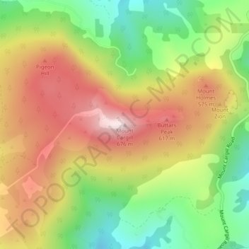
Name: Mount Cargill topographic map, elevation, terrain.
Location: Mount Cargill, Dunedin, Dunedin City, Otago, New Zealand (-45.81314 170.55514 -45.81304 170.55524)
Average elevation: 424 m
Minimum elevation: 183 m
Maximum elevation: 670 m
Other topographic maps
Click on a map to view its topography, its elevation and its terrain.
Saddle Hill
Saddle Hill, Dunedin, Dunedin City, Otago, 9024, New Zealand
Average elevation: 201 m
Waikouaiti River
Waikouaiti River, Dunedin, Dunedin City, Otago, 9510, New Zealand
Average elevation: 12 m
Water of Leith
Water of Leith, Dunedin, Dunedin City, Otago, 9010, New Zealand
Average elevation: 136 m
Quarantine Island/Kamau Taurua
Quarantine Island/Kamau Taurua, Dunedin, Dunedin City, Otago, New Zealand
Average elevation: 6 m