
Brakel topographic map
Interactive map
Click on the map to display elevation.
About this map
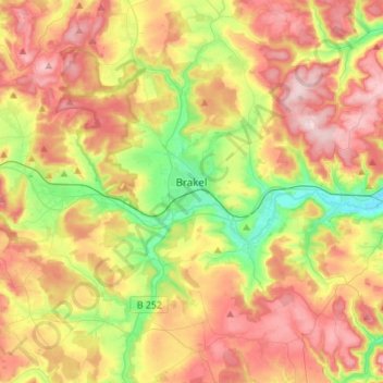
Name: Brakel topographic map, elevation, terrain.
Location: Brakel, Kreis Höxter, Noordrijn-Westfalen, 33034, Duitsland (51.62778 9.06318 51.79796 9.28667)
Average elevation: 232 m
Minimum elevation: 104 m
Maximum elevation: 365 m
Other topographic maps
Click on a map to view its topography, its elevation and its terrain.
Bad Driburg
Duitsland > Noordrijn-Westfalen > Kreis Höxter
Bad Driburg, Kreis Höxter, Noordrijn-Westfalen, 33014, Duitsland
Average elevation: 282 m
Höxter
Duitsland > Noordrijn-Westfalen > Kreis Höxter
Höxter, Kreis Höxter, Noordrijn-Westfalen, 37671, Duitsland
Average elevation: 228 m
Warburg
Duitsland > Noordrijn-Westfalen > Kreis Höxter > Warburg
Warburg, Kreis Höxter, Noordrijn-Westfalen, 34414, Duitsland
Average elevation: 248 m