
Ühlingen-Birkendorf topographic map
Interactive map
Click on the map to display elevation.
About this map
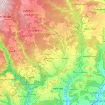
Name: Ühlingen-Birkendorf topographic map, elevation, terrain.
Average elevation: 715 m
Minimum elevation: 380 m
Maximum elevation: 1,100 m
Other topographic maps
Click on a map to view its topography, its elevation and its terrain.
Klettgau
Duitsland > Baden-Württemberg > Landkreis Waldshut
Klettgau, Landkreis Waldshut, Baden-Württemberg, 79771, Duitsland
Average elevation: 469 m
Höchenschwand
Duitsland > Baden-Württemberg > Landkreis Waldshut
Höchenschwand, Verwaltungsverband St. Blasien, Landkreis Waldshut, Baden-Württemberg, 79862, Duitsland
Average elevation: 843 m
Ibach
Duitsland > Baden-Württemberg > Landkreis Waldshut
Ibach, Landkreis Waldshut, Baden-Württemberg, 79875, Duitsland
Average elevation: 820 m
Todtmoos
Duitsland > Baden-Württemberg > Landkreis Waldshut
Todtmoos, Verwaltungsverband St. Blasien, Landkreis Waldshut, Baden-Württemberg, 79682, Duitsland
Average elevation: 977 m