
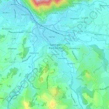
Larroinea topographic map
Interactive map
Click on the map to display elevation.
About this map
Name: Larroinea topographic map, elevation, terrain.
Average elevation: 204 m
Minimum elevation: 146 m
Maximum elevation: 460 m
Other topographic maps
Click on a map to view its topography, its elevation and its terrain.
Citadelle de Saint Jean Pied de Port
France > Nouvelle-Aquitaine > Pyrénées-Atlantiques > Saint-Jean-Pied-de-Port > Portaleburua
Citadelle de Saint Jean Pied de Port, Chemin des Écoliers, Basse-Navarre, Portaleburua, Saint-Jean-Pied-de-Port, Bayonne, Pyrénées-Atlantiques, Nouvelle-Aquitaine, France métropolitaine, 64220, France
Average elevation: 190 m
Lauribar
France > Nouvelle-Aquitaine > Pyrénées-Atlantiques > Saint-Jean-Pied-de-Port
Lauribar, Saint-Jean-Pied-de-Port, Bayonne, Pyrénées-Atlantiques, Nouvelle-Aquitaine, France métropolitaine, 64220, France
Average elevation: 220 m
Uganga
France > Nouvelle-Aquitaine > Pyrénées-Atlantiques > Saint-Jean-Pied-de-Port
Uganga, Saint-Jean-Pied-de-Port, Bayonne, Pyrénées-Atlantiques, Nouvelle-Aquitaine, France métropolitaine, 64220, France
Average elevation: 220 m
Portaleburua
France > Nouvelle-Aquitaine > Pyrénées-Atlantiques > Saint-Jean-Pied-de-Port
Portaleburua, Saint-Jean-Pied-de-Port, Bayonne, Pyrénées-Atlantiques, Nouvelle-Aquitaine, France métropolitaine, 64220, France
Average elevation: 210 m