
Make a donation
Arkansas topographic map
Click on the map to display elevation.
Make a donation
About this map
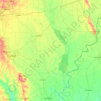
Name: Arkansas topographic map, elevation, terrain.
Location: Arkansas, Arkansas County, Arkansas, United States (33.59025 -92.05985 34.99025 -90.65985)
Average elevation: 58 m
Minimum elevation: 30 m
Maximum elevation: 149 m
Make a donation
Other topographic maps
Click on a map to view its topography, its elevation and its terrain.
Beaver Lake
United States > Arkansas > Benton County > Goshen
Beaver Dam was authorized by the Flood Control Act of 1944 and other following acts. The United States Army Corps of Engineers constructed Beaver Dam during the years 1960-1966, impounding a major part of the White River and creating Beaver Lake and flooding much of the valley including the remains of the…
Average elevation: 392 m
Crater of Diamonds State Park
United States > Arkansas > Pike County > Murfreesboro > Kimberley
Average elevation: 106 m
Make a donation
Make a donation
Make a donation
Make a donation
Make a donation
Make a donation
Make a donation
Dumas
United States > Arkansas > Desha County
According to the United States Census Bureau, the city has a total area of 3.2 square miles (8.4 km2), all land. The city is located in the Delta Lowlands sub-region of the Arkansas Delta, producing a topography which is largely flat.
Average elevation: 50 m
Make a donation
Make a donation
Make a donation
Make a donation
Make a donation
Make a donation
Make a donation
Make a donation
Make a donation
Make a donation
Make a donation
Make a donation
Make a donation
Make a donation
Make a donation
Make a donation
Make a donation
Make a donation