
Thank you for supporting this site ❤️
Make a donation
Make a donation
Los Ríos Region topographic map
Click on the map to display elevation.
Thank you for supporting this site ❤️
Make a donation
Make a donation
About this map
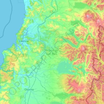
Name: Los Ríos Region topographic map, elevation, terrain.
Location: Los Ríos Region, Chile (-40.68097 -73.72509 -39.28735 -71.59266)
Average elevation: 430 m
Minimum elevation: -2 m
Maximum elevation: 2,781 m
Thank you for supporting this site ❤️
Make a donation
Make a donation
Other topographic maps
Click on a map to view its topography, its elevation and its terrain.
Thank you for supporting this site ❤️
Make a donation
Make a donation
Punta Santa Ana
Chile > Region of Magallanes and Chilean Antarctica > Provincia de Magallanes > Punta Arenas
Average elevation: 5 m
Villa Cerro Castillo
Chile > Aysén Region > Provincia de General Carrera > Río Ibáñez
Average elevation: 379 m
Thank you for supporting this site ❤️
Make a donation
Make a donation