
Village of Manlius topographic map
Interactive map
Click on the map to display elevation.
About this map
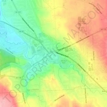
Name: Village of Manlius topographic map, elevation, terrain.
Average elevation: 220 m
Minimum elevation: 145 m
Maximum elevation: 303 m
Other topographic maps
Click on a map to view its topography, its elevation and its terrain.
City of Syracuse
United States > New York > Onondaga County
City of Syracuse, Onondaga County, New York, United States
Average elevation: 172 m
Howlett Hill
United States > New York > Onondaga County > Town of Marcellus
Howlett Hill, Town of Marcellus, Marcellus, Onondaga County, New York, 13108, United States
Average elevation: 320 m
Village of Marcellus
United States > New York > Onondaga County
Village of Marcellus, Town of Marcellus, Marcellus, Onondaga County, New York, 13108, United States
Average elevation: 243 m
Otisco Lake
United States > New York > Onondaga County > Town of Spafford
Otisco Lake, Town of Spafford, Marcellus, Onondaga County, New York, 13108, United States
Average elevation: 338 m
Brewerton
United States > New York > Onondaga County > Town of Cicero
Brewerton, Town of Cicero, Onondaga County, New York, 13029, United States
Average elevation: 118 m
Fairmount
United States > New York > Onondaga County > Town of Camillus
Fairmount, Town of Camillus, Onondaga County, New York, United States
Average elevation: 173 m
Town of Marcellus
United States > New York > Onondaga County
Town of Marcellus, Onondaga County, New York, United States
Average elevation: 294 m
Village of Skaneateles
United States > New York > Onondaga County
Village of Skaneateles, Town of Skaneateles, Onondaga County, New York, United States
Average elevation: 282 m
Nedrow
United States > New York > Onondaga County > Town of Onondaga
Nedrow, Town of Onondaga, Onondaga County, New York, United States
Average elevation: 174 m
Village of Minoa
United States > New York > Onondaga County
Village of Minoa, Town of Manlius, Onondaga County, New York, 13116, United States
Average elevation: 125 m
Village Green
United States > New York > Onondaga County > Town of Van Buren
Village Green, Town of Van Buren, Onondaga County, New York, United States
Average elevation: 130 m
Skanondaga Heights
United States > New York > Onondaga County > Town of Skaneateles
Skanondaga Heights, Town of Skaneateles, Marcellus, Onondaga County, New York, 13108, United States
Average elevation: 291 m
Village of Camillus
United States > New York > Onondaga County
Village of Camillus, Town of Camillus, Onondaga County, New York, United States
Average elevation: 177 m
Westvale
United States > New York > Onondaga County
Westvale, Town of Geddes, Onondaga County, New York, 13219, United States
Average elevation: 168 m
Cardiff
United States > New York > Onondaga County > Town of LaFayette
Cardiff, Town of LaFayette, Onondaga County, New York, 13084, United States
Average elevation: 276 m
Cold Springs
United States > New York > Onondaga County
Cold Springs, Town of Lysander, Onondaga County, New York, 13090, United States
Average elevation: 122 m
Town of De Witt
United States > New York > Onondaga County
Town of De Witt, Onondaga County, New York, United States
Average elevation: 155 m
Town of Camillus
United States > New York > Onondaga County
Town of Camillus, Marcellus, Onondaga County, New York, 13108, United States
Average elevation: 182 m
Marietta
United States > New York > Onondaga County > Town of Marcellus
Marietta, Town of Marcellus, Onondaga County, New York, 13110, United States
Average elevation: 315 m
Amber
United States > New York > Onondaga County
Amber, Town of Otisco, Onondaga County, New York, 13110, United States
Average elevation: 292 m
Town of Clay
United States > New York > Onondaga County
Town of Clay, Onondaga County, New York, United States
Average elevation: 120 m
Town of LaFayette
United States > New York > Onondaga County
Town of LaFayette, Onondaga County, New York, 13084, United States
Average elevation: 327 m
Town of Pompey
United States > New York > Onondaga County
Town of Pompey, Onondaga County, New York, United States
Average elevation: 365 m
Village of Fabius
United States > New York > Onondaga County > Town of Fabius
Village of Fabius, Town of Fabius, Onondaga County, New York, United States
Average elevation: 402 m
Town of Elbridge
United States > New York > Onondaga County
Town of Elbridge, Onondaga County, New York, United States
Average elevation: 160 m
Green Lakes State Park
United States > New York > Onondaga County > Village of Fayetteville > Town of Manlius
Green Lakes State Park, Village of Fayetteville, Town of Manlius, Onondaga County, New York, United States
Average elevation: 166 m
Swift Corner
United States > New York > Onondaga County > Town of Pompey
Swift Corner, Town of Pompey, Onondaga County, New York, 13188, United States
Average elevation: 451 m
Spafford Valley
United States > New York > Onondaga County > Town of Spafford
Spafford Valley, Town of Spafford, Onondaga County, New York, United States
Average elevation: 385 m
Town of Onondaga
United States > New York > Onondaga County
Town of Onondaga, Marcellus, Onondaga County, New York, 13108, United States
Average elevation: 263 m
Onondaga Hill
United States > New York > Onondaga County > Town of Onondaga > Onondaga Hill
Onondaga Hill, Town of Onondaga, Onondaga County, New York, 13207, United States
Average elevation: 243 m
Town of Skaneateles
United States > New York > Onondaga County > Town of Skaneateles
Town of Skaneateles, Onondaga County, New York, United States
Average elevation: 276 m
Village of Fayetteville
United States > New York > Onondaga County
Village of Fayetteville, Town of Manlius, Onondaga County, New York, 13066, United States
Average elevation: 164 m
Jamesville
United States > New York > Onondaga County > Town of De Witt
Jamesville, Town of De Witt, Onondaga County, New York, 13078, United States
Average elevation: 215 m
Town of Manlius
United States > New York > Onondaga County
Town of Manlius, Onondaga County, New York, United States
Average elevation: 179 m
Town of Cicero
United States > New York > Onondaga County
Town of Cicero, Onondaga County, New York, United States
Average elevation: 120 m
Village of Jordan
United States > New York > Onondaga County > Village of Jordan
Village of Jordan, Town of Elbridge, Onondaga County, New York, United States
Average elevation: 138 m
Town of Salina
United States > New York > Onondaga County > Town of Salina
Town of Salina, Onondaga County, New York, United States
Average elevation: 126 m
Village of Tully
United States > New York > Onondaga County
Village of Tully, Town of Tully, Onondaga County, New York, United States
Average elevation: 400 m
Howlett Hill
United States > New York > Onondaga County > Town of Onondaga > Howlett Hill
Howlett Hill, Town of Onondaga, Onondaga County, New York, 13022, United States
Average elevation: 271 m
Stiles
United States > New York > Onondaga County > Town of Van Buren > Stiles
Stiles, Town of Van Buren, Onondaga County, New York, 13164, United States
Average elevation: 130 m
Heath Grove
United States > New York > Onondaga County > Town of Otisco > Heath Grove
Heath Grove, Town of Otisco, Onondaga County, New York, 13110, United States
Average elevation: 294 m
Pitcher Hill
United States > New York > Onondaga County > Town of Salina > Pitcher Hill
Pitcher Hill, Town of Salina, Onondaga County, New York, 13212-3827, United States
Average elevation: 127 m
Solvay
United States > New York > Onondaga County > Town of Geddes > Solvay
Solvay, Town of Geddes, Onondaga County, New York, United States
Average elevation: 149 m
Borodino
United States > New York > Onondaga County > Town of Spafford > Borodino
Borodino, Town of Spafford, Onondaga County, New York, United States
Average elevation: 327 m
Village of Baldwinsville
United States > New York > Onondaga County
Village of Baldwinsville, Town of Lysander, Onondaga County, New York, 13027, United States
Average elevation: 132 m
Bayberry
United States > New York > Onondaga County > Town of Clay > Bayberry
Bayberry, Town of Clay, Onondaga County, New York, 13090, United States
Average elevation: 120 m
Hogsback
United States > New York > Onondaga County > Town of Fabius
Hogsback, Town of Fabius, Onondaga County, New York, 13063, United States
Average elevation: 411 m