
Grayson topographic map
Interactive map
Click on the map to display elevation.
About this map
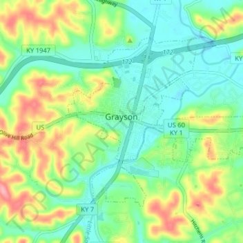
Name: Grayson topographic map, elevation, terrain.
Location: Grayson, Carter County, Kentucky, United States (38.31394 -82.96283 38.34918 -82.89834)
Average elevation: 208 m
Minimum elevation: 170 m
Maximum elevation: 279 m
Other topographic maps
Click on a map to view its topography, its elevation and its terrain.
Wolf
United States > Kentucky > Carter County
Wolf, Carter County, Kentucky, United States
Average elevation: 271 m
Denton
United States > Kentucky > Carter County
Denton, Carter County, Kentucky, 41132, United States
Average elevation: 232 m
Hitchins
United States > Kentucky > Carter County
Hitchins, Carter County, Kentucky, 41146, United States
Average elevation: 215 m
Grahn
United States > Kentucky > Carter County
Grahn, Carter County, Kentucky, 41142, United States
Average elevation: 266 m
Olive Hill
United States > Kentucky > Carter County
Olive Hill, Carter County, Kentucky, 41164, United States
Average elevation: 274 m