
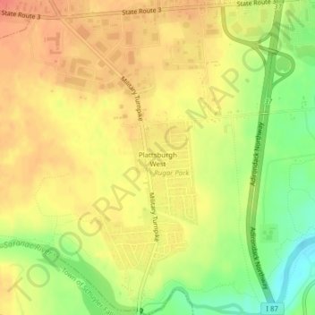
Plattsburgh West topographic map
Interactive map
Click on the map to display elevation.
About this map
Name: Plattsburgh West topographic map, elevation, terrain.
Average elevation: 93 m
Minimum elevation: 60 m
Maximum elevation: 113 m
Other topographic maps
Click on a map to view its topography, its elevation and its terrain.
City of Plattsburgh
United States > New York > Clinton County
City of Plattsburgh, Clinton County, New York, United States
Average elevation: 50 m
Stevens Landing
United States > New York > Clinton County > Town of Black Brook
Stevens Landing, Town of Black Brook, Clinton County, New York, 12912, United States
Average elevation: 385 m
Plattsburg Boat Launch
United States > New York > Clinton County > City of Plattsburgh
Plattsburg Boat Launch, City of Plattsburgh, Clinton County, New York, United States
Average elevation: 36 m
Upper Chateaugay Lake Sandbar
United States > New York > Clinton County > Town of Ellenburg
Upper Chateaugay Lake Sandbar, Town of Ellenburg, Clinton County, New York, United States
Average elevation: 417 m
Town of Schuyler Falls
United States > New York > Clinton County
Town of Schuyler Falls, Clinton County, New York, 12962, United States
Average elevation: 145 m
Village of Rouses Point
United States > New York > Clinton County
Village of Rouses Point, Town of Champlain, Clinton County, New York, 12979, United States
Average elevation: 35 m
West Plattsburgh
United States > New York > Clinton County
West Plattsburgh, Town of Plattsburgh, Clinton County, New York, 12962, United States
Average elevation: 146 m
Town of Mooers
United States > New York > Clinton County
Town of Mooers, Clinton County, New York, United States
Average elevation: 111 m
Ellenburg Depot
United States > New York > Clinton County > Town of Ellenburg
Ellenburg Depot, Town of Ellenburg, Clinton County, New York, United States
Average elevation: 274 m
Merrill
United States > New York > Clinton County > Town of Ellenburg
Merrill, Town of Ellenburg, Clinton County, New York, 12955, United States
Average elevation: 424 m
Russia
United States > New York > Clinton County > Town of Saranac
Russia, Town of Saranac, Clinton County, New York, 12981, United States
Average elevation: 458 m
Village of Dannemora
United States > New York > Clinton County
Village of Dannemora, Town of Dannemora, Clinton County, New York, 12929, United States
Average elevation: 442 m
Cadyville
United States > New York > Clinton County
Cadyville, Town of Plattsburgh, Clinton County, New York, United States
Average elevation: 236 m
Clinton Mills
United States > New York > Clinton County
Clinton Mills, Town of Clinton, Clinton County, New York, United States
Average elevation: 338 m
Lyon Mountain
United States > New York > Clinton County > Town of Saranac
Lyon Mountain, Town of Saranac, Clinton County, New York, United States
Average elevation: 951 m
Churubusco
United States > New York > Clinton County
Churubusco, Town of Clinton, Clinton County, New York, 12923, United States
Average elevation: 354 m
Altona
United States > New York > Clinton County > Town of Altona
Altona, Town of Altona, Clinton County, New York, United States
Average elevation: 196 m
Elsinore
United States > New York > Clinton County > Town of Saranac
Elsinore, Town of Saranac, Clinton County, New York, 12918, United States
Average elevation: 270 m
Valcour Island
United States > New York > Clinton County > Town of Peru
Valcour Island, Town of Peru, Town of Plattsburgh, Clinton County, New York, United States
Average elevation: 34 m
Town of Ellenburg
United States > New York > Clinton County
Town of Ellenburg, Clinton County, New York, United States
Average elevation: 398 m
Au Sable Forks
United States > New York > Clinton County > Town of Black Brook
Au Sable Forks, Town of Black Brook, Clinton County, New York, United States
Average elevation: 238 m
Clayburg
United States > New York > Clinton County > Town of Saranac
Clayburg, Town of Saranac, Clinton County, New York, 12978, United States
Average elevation: 384 m
Mooers Forks
United States > New York > Clinton County
Mooers Forks, Town of Mooers, Clinton County, New York, 12959, United States
Average elevation: 120 m
Sciota
United States > New York > Clinton County
Sciota, Town of Chazy, Clinton County, New York, United States
Average elevation: 114 m
Pleasant Ridge Corners
United States > New York > Clinton County
Pleasant Ridge Corners, Town of Plattsburgh, Clinton County, New York, United States
Average elevation: 78 m
Town of Dannemora
United States > New York > Clinton County
Town of Dannemora, Clinton County, New York, United States
Average elevation: 408 m
Chazy Lake
United States > New York > Clinton County > Town of Dannemora
Chazy Lake, Town of Dannemora, Clinton County, New York, United States
Average elevation: 534 m
Redford
United States > New York > Clinton County > Town of Saranac
Redford, Town of Saranac, Clinton County, New York, 12978, United States
Average elevation: 372 m
Cumberland Head
United States > New York > Clinton County
Cumberland Head, Town of Plattsburgh, Clinton County, New York, United States
Average elevation: 34 m
Mooers
United States > New York > Clinton County > Town of Mooers
Mooers, Town of Mooers, Clinton County, New York, United States
Average elevation: 83 m
High Bank
United States > New York > Clinton County > Town of Saranac
High Bank, Town of Saranac, Clinton County, New York, United States
Average elevation: 473 m
Peasleeville
United States > New York > Clinton County > Town of Peru
Peasleeville, Town of Peru, Clinton County, New York, 12985, United States
Average elevation: 337 m
Ellenburg Center
United States > New York > Clinton County > Town of Ellenburg
Ellenburg Center, Town of Ellenburg, Clinton County, New York, 12934, United States
Average elevation: 383 m
Standish
United States > New York > Clinton County > Town of Saranac
Standish, Town of Saranac, Clinton County, New York, United States
Average elevation: 541 m
Moffitsville
United States > New York > Clinton County > Town of Saranac
Moffitsville, Town of Saranac, Clinton County, New York, 12981, United States
Average elevation: 314 m
Parc
United States > New York > Clinton County
Parc, Town of Plattsburgh, Clinton County, New York, United States
Average elevation: 48 m
South Plattsburgh
United States > New York > Clinton County
South Plattsburgh, Town of Plattsburgh, Clinton County, New York, United States
Average elevation: 67 m
Rocky Point
United States > New York > Clinton County > Cumberland Head
Rocky Point, Cumberland Head, Town of Plattsburgh, Clinton County, New York, United States
Average elevation: 36 m
Champlain Park
United States > New York > Clinton County > City of Plattsburgh
Champlain Park, City of Plattsburgh, Clinton County, New York, United States
Average elevation: 37 m
South Junction
United States > New York > Clinton County
South Junction, Town of Plattsburgh, Clinton County, New York, 12903, United States
Average elevation: 42 m
Woods Falls
United States > New York > Clinton County
Woods Falls, Town of Mooers, Clinton County, New York, United States
Average elevation: 142 m
Ingraham
United States > New York > Clinton County
Ingraham, Town of Chazy, Clinton County, New York, United States
Average elevation: 50 m
Chazy Landing
United States > New York > Clinton County
Chazy Landing, Town of Chazy, Clinton County, New York, 05463, United States
Average elevation: 34 m
Cliff Haven
United States > New York > Clinton County
Cliff Haven, Town of Plattsburgh, Clinton County, New York, 12903, United States
Average elevation: 41 m
Harrigan
United States > New York > Clinton County > Town of Ellenburg
Harrigan, Town of Ellenburg, Clinton County, New York, 12933, United States
Average elevation: 508 m
Dannemora Crossing
United States > New York > Clinton County
Dannemora Crossing, Town of Altona, Clinton County, New York, United States
Average elevation: 278 m
West Chazy
United States > New York > Clinton County
West Chazy, Town of Chazy, Clinton County, New York, 12992, United States
Average elevation: 85 m
Town of Chazy
United States > New York > Clinton County
Town of Chazy, Clinton County, New York, United States
Average elevation: 57 m
Perry Mills
United States > New York > Clinton County > Town of Champlain
Perry Mills, Town of Champlain, Clinton County, New York, United States
Average elevation: 68 m
Coopersville
United States > New York > Clinton County > Town of Champlain
Coopersville, Town of Champlain, Clinton County, New York, 12919, United States
Average elevation: 39 m