
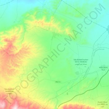
Sidi Abdelmoumen topographic map
Interactive map
Click on the map to display elevation.
About this map
Name: Sidi Abdelmoumen topographic map, elevation, terrain.
Average elevation: 828 m
Minimum elevation: 553 m
Maximum elevation: 1,506 m
Other topographic maps
Click on a map to view its topography, its elevation and its terrain.
Taouloukoult
Maroc > cercle d'M’touga > Taouloukoult
Taouloukoult, caïdat de Touloukoult, cercle d'M’touga, Province de Chichaoua, Marrakech-Safi, Maroc
Average elevation: 1,086 m