
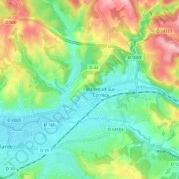
Malemort-sur-Corrèze topographic map
Interactive map
Click on the map to display elevation.
About this map
Name: Malemort-sur-Corrèze topographic map, elevation, terrain.
Average elevation: 177 m
Minimum elevation: 108 m
Maximum elevation: 314 m
Other topographic maps
Click on a map to view its topography, its elevation and its terrain.
Château de Sérignac
France > Nouvelle-Aquitaine > Corrèze > Malemort
Château de Sérignac, Malemort-sur-Corrèze, Malemort, Brive-la-Gaillarde, Corrèze, Nouvelle-Aquitaine, France métropolitaine, 19360, France
Average elevation: 158 m
Venarsal
France > Nouvelle-Aquitaine > Corrèze > Malemort
Venarsal, Malemort, Brive-la-Gaillarde, Corrèze, Nouvelle-Aquitaine, France métropolitaine, 19360, France
Average elevation: 285 m