
Narra topographic map
Interactive map
Click on the map to display elevation.
About this map
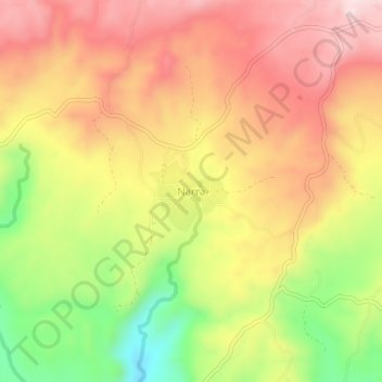
Name: Narra topographic map, elevation, terrain.
Location: Narra, Bayawan, Negros Oriental, Central Visayas, Philippines (9.43126 122.86412 9.47126 122.90412)
Average elevation: 274 m
Minimum elevation: 57 m
Maximum elevation: 438 m
Other topographic maps
Click on a map to view its topography, its elevation and its terrain.
Nangka
Philippines > Negros Oriental > Bayawan
Nangka, Bayawan, Negros Oriental, Central Visayas, 6221, Philippines
Average elevation: 25 m
Banga
Philippines > Negros Oriental > Bayawan > Cabcabon Hills
Banga, Cabcabon Hills, Bayawan, Negros Oriental, Central Visayas, 6221, Philippines
Average elevation: 48 m