
Dharma topographic map
Interactive map
Click on the map to display elevation.
About this map
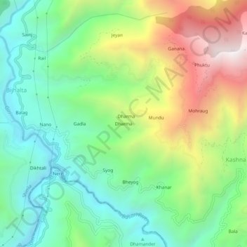
Name: Dharma topographic map, elevation, terrain.
Location: Dharma, Theog, Shimla, Himachal Pradesh, 171226, India (31.00797 77.37148 31.04797 77.41148)
Average elevation: 1,575 m
Minimum elevation: 1,107 m
Maximum elevation: 2,414 m
Other topographic maps
Click on a map to view its topography, its elevation and its terrain.
Deha
India > Himachal Pradesh > Theog
Deha, Theog, Shimla District, Himachal Pradesh, India
Average elevation: 2,048 m
Shilaru
India > Himachal Pradesh > Theog
Shilaru, Theog, Shimla District, Himachal Pradesh, 171212, India
Average elevation: 2,329 m